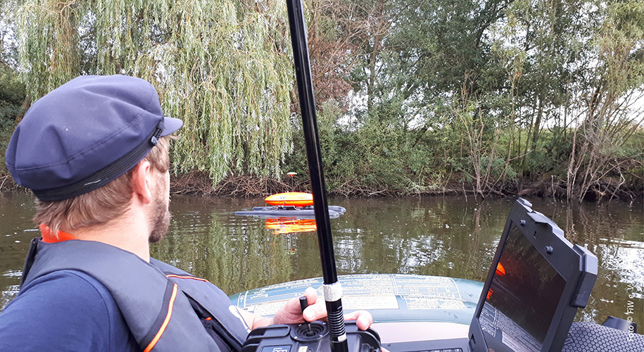
RiverView® is a monitoring system for running waters that records data with high resolution in time and space, which is geo-referenced and reproducible. This way, it provides an important basis for finding solutions in water management. The focus is on the recording of small to medium-sized rivers.
The monitoring of running waters is an important basis for water management planning processes with the goal to make water body qualities better. Especially since the start of the European Water Framework Directive (EC-WFD), but also regarding flood protection, the overall view is becoming more and more important. Up to now, river data have mainly been collected by stationary measuring systems and time-consuming watercourse inspections.
The focus is on the further development of an autonomous monitoring catamaran as a carrier platform for chemical-physical sensors and in addition optical and sonar-based 360° water scanning sensors. The collected water data will be transferred into a bimodal, spatio-temporal geodatabase management system, visualised with the help of various interfaces (app, web portal) and made available to the end user.
The RiverView® system allows the objective recording of the condition of flowing waters - above and below the water surface. The full recording makes it possible to identify sources of pollution and, as a result, to plan actions according to the requirements.

Range of services
- High space and time resolution data collection on water topography using single-beam echo sounder and other acoustic and optical survey methods
- Exact positioning of all taken values in position and height with an inertial measuring unit (IMU) coupled with two-antenna RTK-GNSS monitoring
- Recording of chemical-physical water quality parameters with two multiparameter sensors
- Recording of hydraulic parameters with a modular ADCP device
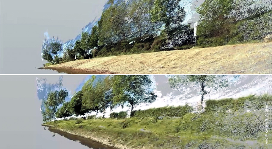
- 360° camera for all-round recording and photogrammetric mapping
- Suitability for investigative monitoring thanks to flexibility in terms of space
- Demonstration of water body development processes by repeated inspection of rivers along the same route
- Further processing of 360° over- and underwater images into an all-round image world with virtual reality elements and 3D models to help with the communication of river engineering activities.
More information at bmbf.nawam-rewam.de/projekt/riverview
From research into practice
With the end of the RiverView® joint research project, the next step will be not only to further develop the technology, but also to commercially use the results, for example by developing a sustainable business model. Together with small and medium-sized companies, we are working on transfer research projects to increase the system's range of services.
Lake Aasee (Germany) – Analysis to understand the system of an extreme situation
The extreme weather conditions in 2018 had a direct effect on water bodies all over Germany. Low water discharges and the resulting extremely low water levels in combination with high temperatures led to critical situations in many flowing and standing waters. A particularly dramatic situation happened at Lake Aasee in Münster (Germany). On the morning of August 9th, 2018, suddenly a lot of fish died. The increasing number of extreme weather situations shows the need to develop adaptation processes for flowing waters, lakes and reservoirs. A full understanding of the system creates the necessary conditions to handle these challenges. In this context, flexible and high-resolution water body monitoring offers the collection of data for a full system understanding and improved water body management.
Shallow lake management in the face of climate change
After the extreme weather event in August 2018, the exact reason for the fish kill had to be clarified. The understanding of the process serves as a basis for developing future preventive and acute management actions. Theoretically, possible procedures like taking out sediment or aerating the lake must be tested for their effectiveness and economic efficiency. For this reason, the RiverView® team of the FiW analysed the sediment thickness with the help of an echo sounding analysis. They also analysed the potential of nutrient release under critical oxygen conditions. The sensor technology of the RiverView® system was combined with sediment analysis in the laboratory. The echosounder data includes points with spatial position and height values, which are used to create a digital terrain model, just like in a river bed study. Echo sounder use has also shown to be an efficient tool for river bathymetry (mapping of the river bed) in several flowing waters like the Niers and the Lippe (both rivers in Germany). This spatially highly accurate and still efficient data collection gives the essential data basis for the development of a numerical shallow lake model by the Research Institute for Ecosystem Analysis and Assessment at RWTH Aachen University (gaiac e. V.). The goal of the scenario analysis is to evaluate options for actions to avoid or overcome extreme situations similar to those in summer 2018.
Costumer: City of Münster
Partner on subcontract: Research Institute for Ecosystem Analysis and Assessment at RWTH Aachen University (gaiac e. V.)
The input of organic or mineral sediments generally leads to a decrease in the reservoir volume of dams. However, the rate of volume change depends on many local and technical boundary conditions. An estimation of the rate of change is uncertain. Dam operators are therefore dependent on the measurement of the watercourse bed and the upper sludge layer. The Perlenbach water supply association contracted the FiW to make a bathymetric survey (mapping) of the Perlenbach dam in spring 2019. With the help of echo sounder recordings in different frequency ranges, we analysed the bottom of the reservoir and the highest sludge layer. This offered the operator a first full-scale map of the reservoir bottom and updated volume calculation of the available reservoir space since the opening of the dam in 1956.
Customer: Water supply association Perlenbach
The entire range of monitoring, currently possible with the RiverView® system, was used also on the Rhine. Since May 2019, the RiverBoat has been accompanying one of the first Blue Belt Germany model projects for the German Federal Institute of Hydrology (BfG). This includes measuring the realization of the riverbank transformation on the Rhine at Mainz-Laubenheim. The model project "River bank Renaturation Laubenheim" focuses on the development of a natural sliding bank over a length of about 2 km. FiW collects high-resolution monitoring data for the BfG to support the project:
- Mapping of the river bed in the area of the model project between the navigation channel and the bank with the help of an echo sounder
- flow velocities in two areas of the model project
- Sediment profiles with a sub bottom profiler
- Image recording above and below water
- Photogrammetric mapping of the shore area based on the image recordings
In the area between the navigation channel and the shore, the RiverBoat can show its full potential. In this shallow water area, conventional measurement methods reach their limits even on the Rhine.
Customer: German Federal Institute of Hydrology, Koblenz (BfG)
Partner: Geodetic Institute and Chair of Construction Informatics and Geoinformation Systems (gia), RWTH Aachen University
The RiverView® system was used in 2019 on the Weser under very restrictive boundary conditions. In August and September 2019, the FiW supported the water monitoring of six old gravel lakes on the Middle Weser north of Minden. These old gravel lakes, which have been protected for some time, are the habitat of extremely sensitive animal and plant species. Therefore, access to these waters for monitoring could only be allowed by the responsible nature conservation authority for one month and only under strict conditions. In the end, only the RiverBoat could guarantee a minimally invasive analysis and the lowest possible disturbance on and around the lakes.
Again, during this operation, different parameters were recorded in a highly efficient way:
- Water bottom of the excavation waters by an echo sounder
- Sediment profiles with a sub bottom profiler
- Image recording above and under water
- Photogrammetric mapping of the shore area based on the image recordings
The RiverBoat was also used in this Blue Ribbon Germany model project due to its special technical characteristics and was even able to prevail over the use of drones here.
Customer: German Federal Administration of Waterways and Shipping (WSV)
Partner: PHOCAD GmbH
Contact
Dr. sc. Dipl.-Ing. Frank-Andreas Weber
+49 241 80 2 68 25 /
E-Mail
Project Partner
DBM Dr. Buckup e. K.; GEO-DV GmbH; SEBA Hydrometrie GmbH & Co. KG; Evologics GmbH; Institute of Hydraulic Engineering and Water Resources Management (IWW), RWTH Aachen University; Geodetic Institute and Chair of Construction Informatics and Geoinformation Systems (gia), RWTH Aachen University; Water board Eifel-Rur; Cooperative of the river Emscher /Association of the river Lippe
Funding / Supervisor
German Federal Ministry of Education and Research (BMBF)
Research center Jülich (Forschungszentrum Jülich)
Download
Project flyer (DE)
PDF (1,6 MB)